
Bike in Corner of Bled: Discover the scenic surroundings of Lake Bled on two wheels
Bike in Corner of Bled cycling guide — 16 cycling routes around Bled with GPX files for tracking in the field.
Ask the AI cycling guide
Not sure which of the 16 cycling tours suits you? Ask our AI route guide – for example “easy asphalt tours under 15 km” – and get exact data from the guidebook: distance, climbing, gradient and surface.
Plan next season’s rides – or give the guide as a gift to a cyclist.
📲 Simply open Amazon (or your Kindle app), search for “Bike in Corner of Bled” — or click below for your market:
🚴♂️🏔️
Download Kindle reader
You can download the Kindle reader for free to your smartphone at the link on the Amazon website .

For Android phones, you can download the reader for free on Google Play .

Download a tracking app
For tracking GPX routes in the field, we recommend the Bergfex/Tours app:
or the OruxMaps GP app:
or the Locus Map Outdoor Navigation app:
GPX User Manual
The video shows how to find a route in the Kindle guide, download the GPX file, and upload it to Bergfex for tracking in the field.
- Find the desired route in the Kindle guide and tap the GPX link
- The GPX file is downloaded to your phone
- Tap the file and select Bergfex/Tours
- Import as Tour and start navigation
16 Unforgettable Cycling Routes
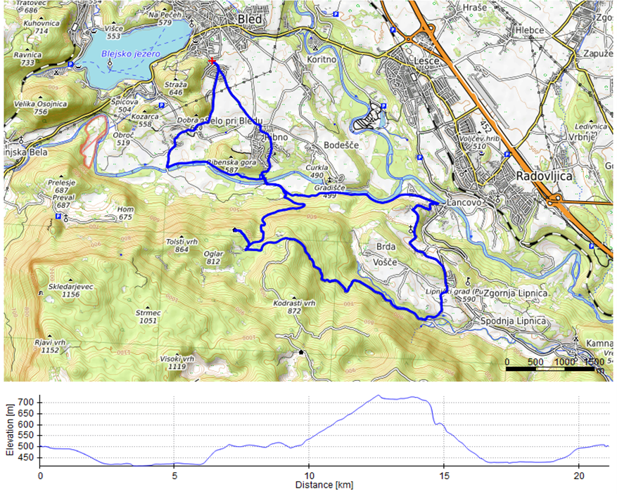
1. HUNTER’S HUT
Variant 1a
Distance: 20.08 km
Climbing / descent: 450 m / 450 m
Average gradient (ascent / descent): 4.2 % / 4.8 %
Maximum gradient: 23.2 %
Surface: Asphalt, gravel, forest road, forest track
Difficulty: Hard. Long ascent to the hunter’s hut, hard descent to the Sava Bohinjka.
Cycling time: ~3 h 12 min
Bike type: mountain bike (MTB)
Variant 1b
Distance: 20.72 km
Climbing / descent: 461 m / 461 m
Average gradient (ascent / descent): 4.4 % / 4.8 %
Maximum gradient: 22.0 %
Surface: Asphalt, gravel, forest road, forest track
Difficulty: Hard. Long ascent to the hunter’s hut, hard descent to the Sava Bohinjka.
Cycling time: ~2 h 54 min
Bike type: mountain bike (MTB)
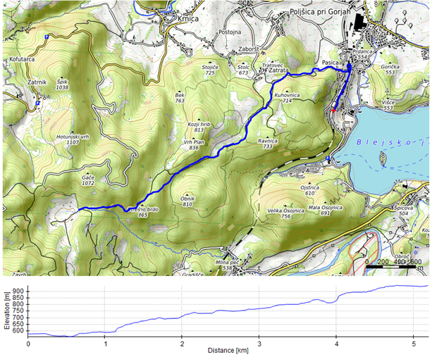
2. SHEPHERDS’ ROUTE
Distance (one way, to Rčitno): 4.55 km
Climbing / descent (one way): 373 m / 373 m
Average gradient (ascent, one-way route): 8.4 %
Maximum gradient: 20.8 %
Surface: Asphalt, gravel
Difficulty: Hard. Ascent to Rčitno.
Cycling time: approx. 1 to 1.5 hours (to Rčitno)
Bike type: mountain bike (MTB)
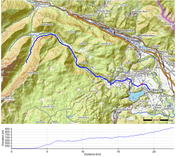
3. TRIGLAV NATIONAL PARK
Variant 3a
Distance (one way, to Krma): 24.5 km
Climbing / descent (one way): 456 m / 95 m
Average gradient (ascent / descent): 2.6 % / 1.3 %
Maximum gradient: 9.9 %
Surface: Asphalt, gravel, forest road
Difficulty: Medium. Ascent to Krnica and the hut in Krma.
Cycling time: approx. 2.5 to 3.5 hours (towards the Krma valley)
Bike type: mountain bike (MTB), gravel
Variant 3b
Distance (one way, to Krma): 23.14 km
Climbing / descent (one way): 438 m / 77 m
Average gradient (ascent / descent): 2.5 % / 1.4 %
Maximum gradient: 9.9 %
Surface: Asphalt, gravel, forest road
Difficulty: Medium. Ascent to Krnica and the hut in Krma.
Cycling time: approx. 2.5 to 3.5 hours (towards the Krma valley)
Bike type: mountain bike (MTB), gravel
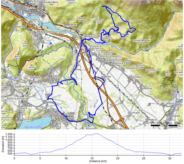
4. VALVASOR HUT: KARAVANKE CHALLENGE
Distance: 32.36 km
Climbing / descent: 866 m / 866 m
Average gradient (ascent / descent): 5.9 % / 5.7 %
Maximum gradient: 25.0 %
Surface: Gravel, forest road, forest track
Difficulty: Challenging. Long ascent to Valvasor’s hut and two shorter climbs: to Breg and (short) back to Bled.
Cycling time: approx. 4–6 hours
Bike type: mountain bike (MTB)
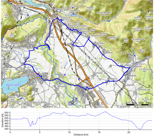
5. CULTURAL HERITAGE TRAIL
Distance: 23.87 km
Climbing / descent: 230 m / 230 m
Average gradient (ascent / descent): 2.1 % / 1.9 %
Maximum gradient: 12.1 %
Surface: Asphalt, gravel
Difficulty: Moderate.
Cycling time: 3–3.5 hours
Bike type: gravel, touring
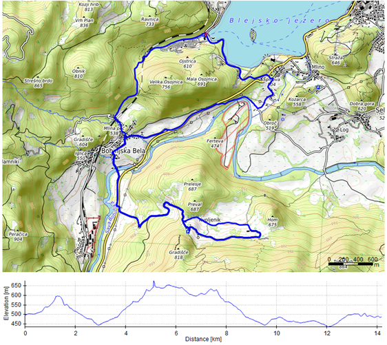
6. STEEP SLOPES ABOVE SAVA BOHINJKA RIVER
Variant 6a (Velika Zaka – Bohinjska Bela – Kupljenik – Selo – Mlino – Velika Zaka)
Distance: 11.93 km
Climbing / descent: 388 m / 388 m
Average gradient (ascent / descent): 6.1 % / 7.3 %
Maximum gradient: 21.8 %
Surface: Asphalt, gravel, forest road, forest track
Difficulty: Hard.
Cycling time: 2–3 hours (for experienced cyclists)
Bike type: mountain bike (MTB), downhill
Variant 6b (Velika Zaka – Bohinjska Bela – Kupljenik – Bohinjska Bela – Selo – Velika Zaka)
Distance: 14.17 km
Climbing / descent: 420 m / 420 m
Average gradient (ascent / descent): 6.3 % / 6.0 %
Maximum gradient: 21.0 %
Surface: Asphalt, gravel, forest road, forest track
Difficulty: Moderate.
Cycling time: 2–3 hours
Bike type: mountain bike (MTB), gravel
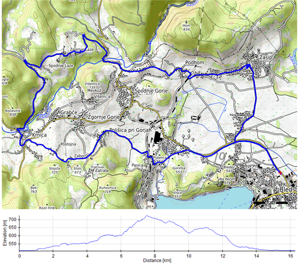
7. NORTHERN SLOPES OF BLED
Variant 7a (Bled – Zasip – Podhom – Zgornje Laze – Spodnje Laze – Krnica – Poljšica – Bled)
Distance: 15.81 km
Climbing / descent: 269 m / 269 m
Average gradient (ascent / descent): 3.5 % / 3.4 %
Maximum gradient: 12.3 %
Surface: Asphalt
Difficulty: Moderate.
Cycling time: 2–3 hours (for experienced cyclists)
Bike type: gravel, road bike
Variant 7b (Bled – Zasip – Podhom – Višelnica – Mevkuž – Grabče – Krnica – Poljšica – Bled)
Distance: 11.96 km
Climbing / descent: 167 m / 167 m
Average gradient (ascent / descent): 2.7 % / 2.9 %
Maximum gradient: 12.7 %
Surface: Asphalt
Difficulty: Light to medium (due to some climbs).
Cycling time: 2–3 hours (for experienced cyclists)
Bike type: gravel, road bike
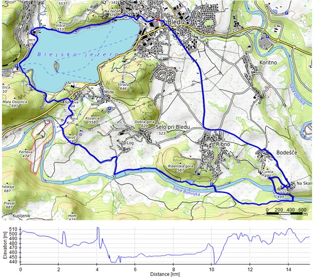
8. FAMILY EXCURSION BY THE SAVA BOHINJKA
Distance: 15.24 km
Climbing / descent: 184 m / 184 m
Average gradient (ascent / descent): 2.4 % / 2.5 %
Maximum gradient: 11.8 %
Surface: Asphalt, gravel
Difficulty: Light.
Cycling time: 2–3 hours (for experienced cyclists)
Bike type: gravel
9. AFTERNOON TRIP TO ZATRNIK
Variant 9a (Camping Velika Zaka – Bled Jezero railway station – Spodnje Gorje – Zgornje Gorje – Krnica – Zatrnik)
Distance: 17.15 km
Climbing / descent: 383 m / 383 m
Average gradient (ascent / descent): 4.5 % / 4.5 %
Maximum gradient: 12.6 %
Surface: Asphalt
Difficulty: Medium (long ascent).
Cycling time: 2–3 hours
Bike type: road bike, gravel
Variant 9b (Velika Zaka – Bled Jezero – Spodnje Gorje – Zgornje Gorje – Krnica – Zatrnik – Krnica – Poljšica – Velika Zaka)
Distance: 17.31 km
Climbing / descent: 446 m / 458 m
Average gradient (ascent / descent): 4.7 % / 5.6 %
Maximum gradient: 19.4 %
Surface: Asphalt
Difficulty: Medium (long ascent).
Cycling time: 2–3 hours
Bike type: road bike, gravel
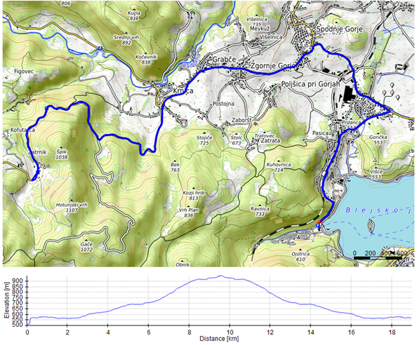
10. POKLJUKA CHALLENGE
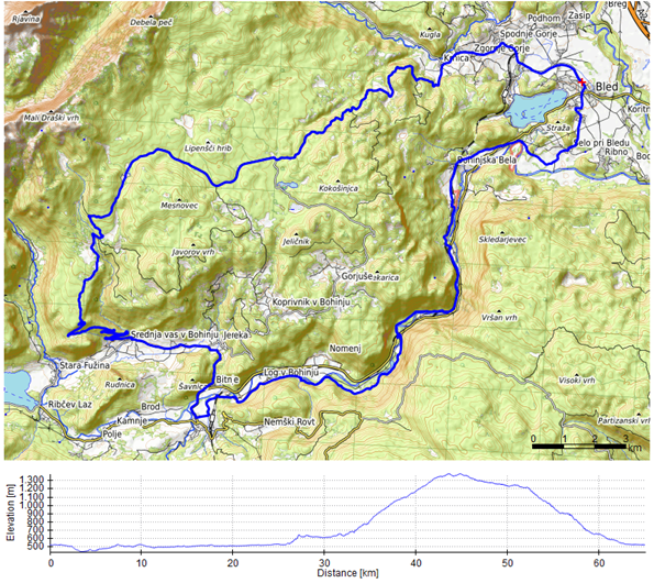
Variant 10a (Bled – Selo – Bohinjska Bela – Bohinjska Bistrica – Bitnje – Srednja vas – Uskovnica – Rudno polje – Zgornje Gorje – Spodnje Gorje – Bled)
Distance: 64.65 km
Climbing / descent: 1192 m / 1192 m
Average gradient (ascent / descent): 3.8 % / 3.7 %
Maximum gradient: 20.1 %
Surface: Asphalt, gravel, forest road
Difficulty: Hard (long ascent).
Cycling time: 6.5–7.5 h (MTB/gravel) · 4–5.5 h (e-bike)
Bike type: mountain bike (MTB), gravel, e-bike
Variant 10b (Bled – Selo – Bohinjska Bela – Bohinjska Bistrica – Danica Brod campsite – Studor – Srednja vas – Uskovnica – Rudno polje – Zgornje Gorje – Spodnje Gorje – Bled)
Distance: 67.01 km
Climbing / descent: 1158 m / 1158 m
Average gradient (ascent / descent): 3.3 % / 3.8 %
Maximum gradient: 19.3 %
Surface: Asphalt, gravel, forest road
Difficulty: Hard (long ascent).
Cycling time: 6.5–7.5 h (MTB/gravel) · 4–5.5 h (e-bike)
Bike type: mountain bike (MTB), gravel, e-bike
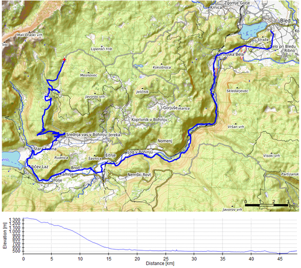
11. DESCENT FROM RUDNO POLJE TO BLED
Distance: 48.65 km
Climbing / descent: 284 m / 284 m
Average gradient (ascent / descent): 2.0 % / 3.4 %
Maximum gradient: 12.4 %
Surface: Asphalt, gravel, forest road
Difficulty: Moderate to hard.
Cycling time: approx. 4 to 5 hours
Bike type: mountain bike (MTB), gravel, e-bike
12. CYCLING EXPERIENCE ALONG SAVA BOHINJKA
Distance: 27.69 km
Climbing / descent: 236 m / 236 m
Average gradient (ascent / descent): 2.1 % / 1.5 %
Maximum gradient: 11.6 %
Surface: Asphalt
Difficulty: Easy to moderate.
Cycling time: 2.5 to 3.5 hours
Bike type: gravel
Download route: 12
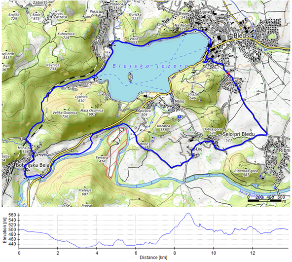
13. BETWEEN SAVA AND OJSTRICA
Distance: 13.78 km
Climbing / descent: 238 m / 238 m
Average gradient (ascent / descent): 4.0 % / 3.1 %
Maximum gradient: 17.9 %
Surface: Asphalt, gravel, forest road
Difficulty: Moderate.
Cycling time: approx. 1.5 to 2 hours
Bike type: gravel
14. FROM HLAPON TO PERON ALONG SAVA BOHINJKA
Variant 14a (Bled – Bodešče – Sava – Velika Zaka – Rečica – Podhom – Bled)
Distance: 15.44 km
Climbing / descent: 169 m / 169 m
Average gradient (ascent / descent): 2.6 % / 2.2 %
Maximum gradient: 10.6 %
Surface: Asphalt, gravel
Difficulty: Medium.
Cycling time: 2 to 3 hours
Bike type: gravel
Variant 14b (Bled – Bodešče – Sava – Bohinjska Bela – Rečica – Podhom – Bled)
Distance: 20.32 km
Climbing / descent: 260 m / 260 m
Average gradient (ascent / descent): 2.7 % / 2.5 %
Maximum gradient: 17.0 %
Surface: Asphalt, gravel, forest road, forest track
Difficulty: Moderate.
Cycling time: 2.5 to 3.5 hours
Bike type: gravel, mountain bike (MTB)
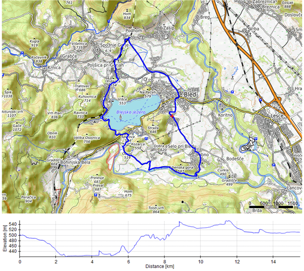
15. BLED CYCLING TOUR: FROM VILLAGE TO VILLAGE
Distance: 28.32 km
Climbing / descent: 651 m / 651 m
Average gradient (ascent / descent): 4.2 % / 5.2 %
Maximum gradient: 23.4 %
Surface: Asphalt, gravel, forest road, forest track
Difficulty: Hard, 2 steep climbs, 1 descent.
Cycling time: approx. 3.5 to 4.5 hours
Bike type: mountain bike (MTB), gravel
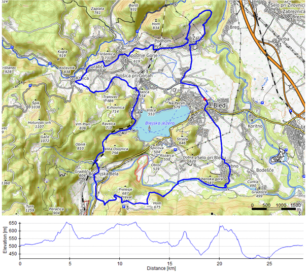
16. ALONG THE EDGES OF POKLJUKA
Distance: 31.16 km
Climbing / descent: 1002 m / 1072 m
Average gradient (ascent / descent): 6.6 % / 7.0 %
Maximum gradient (ascent / descent): 24.5 % / −19.4 %
Surface: Asphalt, gravel, forest road, forest track, rocky terrain
Difficulty: Hard.
Cycling time: 4–6 hours (mountain bike)
Bike type: mountain bike (MTB), gravel
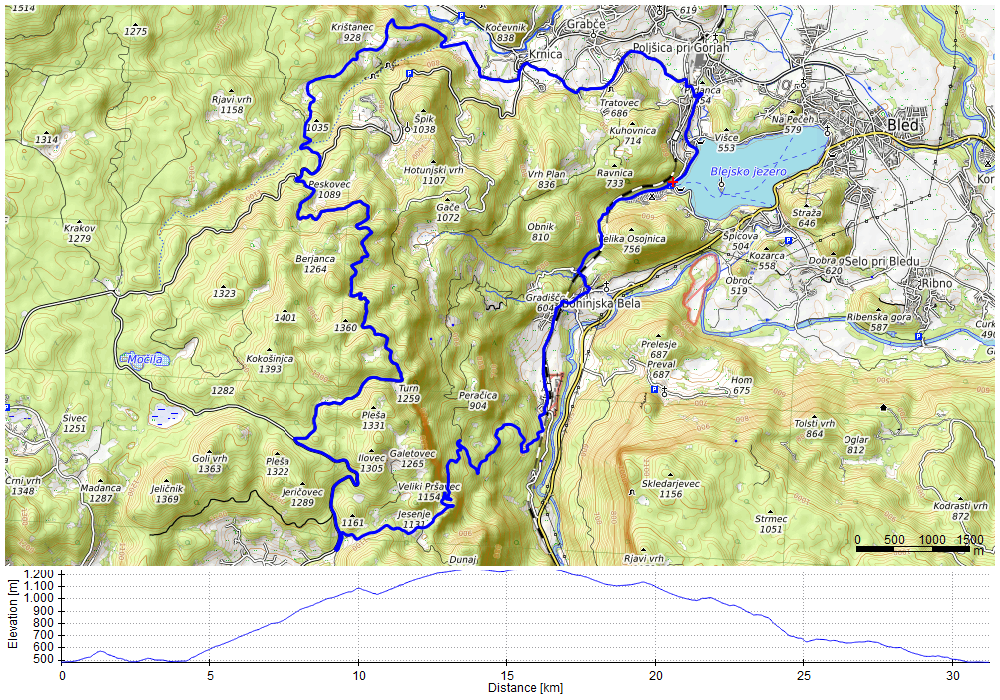
Ask the AI cycling guide
Not sure which of the 16 cycling tours suits you? Ask our AI route guide – for example “easy asphalt tours under 15 km” – and get exact data from the guidebook: distance, climbing, gradient and surface.
Enjoy reading and cycling in Bled!

As an Amazon Associate I earn from qualifying purchases.